Project Leadership
Hydraulic Modeling Task Lead
Pittsburgh Water Wet Weather Program
Lead hydraulic modeling strategy, technical review, and delivery coordination for one of Pittsburgh's most complex wet-weather initiatives.
Since Jan 2024
Unlock badges by exploring the site.
Delivering technical solutions driven by emerging technologies.
Expertise in , , and .
• & • Pittsburgh


Set of tools, platforms, and technologies.


Leading Hydrologic & Hydraulic modeling projects for large utilities, including task leadership for Pittsburgh Water's Wet Weather Program. Developing innovative tools under the Office of Applied Technology while supervising and mentoring staff.
Leading Hydrologic & Hydraulic modeling projects for large utilities, including task leadership for Pittsburgh Water's Wet Weather Program. Developing innovative tools under the Office of Applied Technology while supervising and mentoring staff.
Project and formal roles leading others in tasks, technical advances, and technology management.
Notable Project and Program Leads
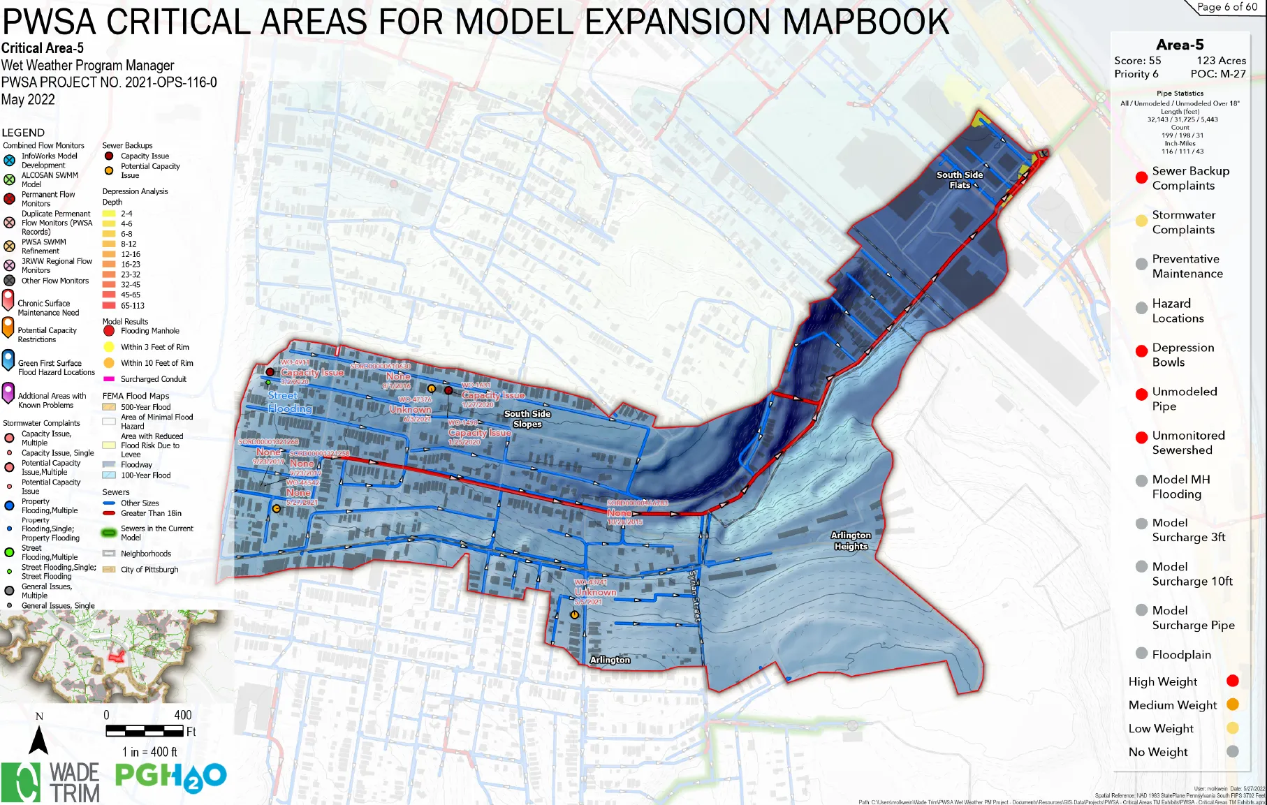
Pittsburgh Water Wet Weather Program
Lead hydraulic modeling strategy, technical review, and delivery coordination for one of Pittsburgh's most complex wet-weather initiatives.
Formal Roles
Other Roles
Pittsburgh Water Wet Weather Program
Lead hydraulic modeling strategy, technical review, and delivery coordination for one of Pittsburgh's most complex wet-weather initiatives.
Recognitions, awards, and public-facing contributions across innovation and technical communication.

Awarded for outstanding contributions to innovation and technical excellence.

Wade Trim
Leadership2024-2025
Selected for intensive leadership development program

Independent
Public Speaking2008
Effective Communications
Student
Award2011
ASCE EWRI Conference


Recent features, mentions, and updates from across the web.

Discover how Wade Trim accelerates high-fidelity simulations with Dell Pro Max workstations and NVIDIA RTX PRO GPUs, reducing runtimes from 48 to 8 hours.
Read Article
Contributing to the SWAN Americas Alliance research project focusing on the role of Agentic AI in the water sector.
Read Article
Khalid Khan and Ross Volkwein joined Wade Trim's Water Resources Group in Pittsburgh, bringing expertise in H&H modeling and stormwater management.
Read Article
A Swanson School student earned first place in a nationwide ASCE competition, highlighting standout engineering talent.
Read ArticleA collection of projects showcasing work in Hydraulic Modeling, GIS, and custom software solutions.
Personal productivity and time-tracking web app (Next.js/React + Supabase on Ver...
Provided QAQC of annual CSO stats modeling and claculations including review of ...
A rainfall event-analysis web app that ingests rain gauge and radar records, sep...
A one-click watershed delineation tool: pick a point and it delineates the contr...
A unified front end for pulling environmental and climate data from nine-plus pr...
A browser-based plot digitizer that turns charts and graphs trapped in PDFs or i...
A SWMM optimization app that runs a genetic algorithm (NSGA-II) across many cand...
A desktop toolkit for SWMM5-RAIN radar-rainfall (.rff) binary files: read, visua...
A .NET add-in that bakes Wade Trim’s GIS standards directly into ArcGIS Pro — sy...
A single-page app for water-supply mass-balance modeling — balancing sources, de...
An ArcGIS Pro Python toolbox of GIS utilities — including an optimized in-memory...
Level of service and resiliency analysis for municipal water systems.
A desktop tool that computes combined-sewer-overflow percent capture directly fr...
Advisor role for ongoing H&H modeling work in the Four Mile Run shed including m...
Supported calibration reviews for the Metropolitan Sewer Authority of Greater Ci...
Provided QAQC of annual CSO stats modeling and claculations including review of ...
Provided QA/QC oversight, technical guidance, and strategic direction for statew...
Originated and led development of an enterprise platform to unify H&H modeling w...
Tool for flow-monitoring data review and calibration support: flow data QA/QC, i...
Supported the Great Lake Water Authority on the T2 44 Valve Project, including d...
Supporting water model calibration and design to size a new pump station and gro...
Supported Brevard County Utilities on the South Beaches project, including revie...
Various activities to support the tunnel program including data processing and s...
Led consolidation of disparate GIS sources and paper mapping into a single autho...
Developed a Python tool to interface with model .out files and pull requested .t...
Working with existing GIS team on this project, evaluated and troubleshot waters...
Cleaned up and standardized the municipality's zoning GIS data and developed an ...
Reviewed several consultant-submitted calibrations as part of an ongoing review ...
Advised on GIS modernization planning; standardized and validated sanitary, stor...
Supported GIS team in the transformation of GPS survey data, resolved quality is...
Various support for H&H model review and data processing activities.
Supported expansion and client adoption of a SharePoint/M365-based digital deliv...
Developed mapping and elevation profiles, including GIS-based data sharing tools...
Used Cartegraph to manage assets for a landfill client.
ArcGIS Pro Python toolbox that bulk-exports every layout in a project to PDF/ima...
Lead engineer for a $17M contract managing a 100-meter flow monitor plan and SWM...
Led development, testing, and deployment of an autocalibration toolkit for SWMM-...
Supported the Northeast Ohio Regional Sewer District on the Alts SOT Gate effort...
Embedded on-site at the Cleveland Water Department, I documented existing water ...
I worked on the LMCPR PCMP project, focusing on the review and guidelines relate...
Built a Power BI dashboard to ingest groundwater well readings from IoT sensors.
Supported SWMM model calibration for the Metropolitan Sewer District of Cincinna...
Development of an HEC-HMS model to determine Probable Maximum Flood elevation fo...
Development of an HEC-HMS model to determine Probable Maximum Flood elevation fo...
Worked with the Authority to determine site locations for 10 flow meters and thr...
Assisted Smith Township in the selection and purchase of a Trimble R2 GNSS recei...
The Moon Township Municipal Authority was experiencing flooding near one of its ...
Georeferencing old paper maps into a GIS system map and configuration of GIS dat...
Built out their GIS from unorganized spatial data and established an ArcGIS Onli...
I completed the upgrade of an existing WaterCAD hydraulic model to an InfoWater ...
Built system map for WEWJA using hundreds of As-built drawings. Combined data in...
H&H modeling of the McKeesport Long Run sewershed and pump station to respond to...
Created a zoning map using old paper maps and migrated it to ArcGIS Online for a...
The development of the Hampton-Shaler Water Authority's first modern water distr...
Secured over $1.2M in ALCOSAN GROW grant funding for green infrastructure and se...
Created a 3D visualization rendering walkthrough of a new WWTP design to demonst...
Created a zoning map using a decades-old paper map and updated it through ordina...
Completed MS4 permit for Stowe Township including development of MS4 mapping and...
H&H modeling of the McKeesport, Dravosburg, and Duquesne combined sewer systems ...
Integrated system updates into the Authority’s water distribution model and supp...
H&H study of waste disposal site to determine H&H effect on streams and neighbor...
Calibrated an H&H model consisting of five flow monitors, a pump station, a forc...
Secured over $1.2M in ALCOSAN GROW grant funding for green infrastructure and se...
Completed H&H report for the enclosure of a stream along Mansfield Road and the ...
Completed H&H modeling and evaluation following failure of CSO Regulator No. 1; ...
Assisted the design team by creating a calibrated H&H model to determine design ...
Assisted the design team by creating a calibrated H&H model to determine design ...
Following the acquisition of Millcreek Township Water Authority, I oversaw the c...
Leveraging existing GIS and as-built data, a water model was constructed and cal...
Performed full stormwater management design and permitting for a new Admin & Per...
Completed MS4 Exemption permit for New Eagle Borough including development of MS...
Completed MS4 General permit for Oakdale Borough including development of MS4 ma...
Completed MS4 General permit for Canonsburg Borough including development of MS4...
Developed Survey123 Form with data validation and dependencies along with a dash...
Completed MS4 Exemption permit for Cokeburg Borough including development of MS4...
Completed MS4 General permit for Lincoln Borough including development of MS4 ma...
Completed MS4 General permit for North Belle Vernon Borough including developmen...
To come into compliance with PA DEP, KVWPCA communities completed sewer separati...
Utilized publicly available permits for gas wells in and around the township to ...
I worked on various GIS projects focused on data management and visualization us...
Updated GIS database using As-builts and constructed truck maps.
Migrated GIS data from GeoPlan to ArcGIS Online. Developed a GPS collection prog...
Determined spillway slopes and velocities, and supported grading tasks. Key focu...
I maintained and updated GIS data for various waterline and sewer projects over ...
I completed E&S and PCSM design and permitting for two pump stations and accompa...
Supported Union Electric Steel on an NPDES modification by reviewing past submis...
Created a system map using as-built drawings and migrated it to the ArcGIS Onlin...
Led stormwater site plan design and permitting for a new sanitary sewer pump sta...
I completed design and permitting for a small culvert replacement for NHTMA.
Completed MS4 General permit for Carnegie Borough including development of MS4 m...
Updated system sewer and water mapping and migrated it to ArcGIS Online.
Completed H&H modeling of the Chartiers and Brush Run Interceptors and associate...
Supported Fairfield Southpointe on the site plan, including checking hydraulic c...
Updated the system map and worked with Precision Laser to set up a collection pr...
Secured over $1.2M in ALCOSAN GROW grant funding for green infrastructure and se...
Supported The Buncher Company on Jackson Pointe Phases 3 and 4, including review...
KLH Engineers had been exploring the idea of an intranet to facilitate basic bus...
Created SketchUp rendering for condo development plan to ensure client and stake...
Working with a small team, I helped to develop the technical aspects of a new in...
Python/arcpy tool that batch-exports ArcMap layouts and map series to PDF/image ...
As a team member on a project to prepare a siting certificate for a new power pl...
Supported RDL Architects, Inc. on the Hillcrest project, including reviewing ref...
Coordinating Utilities and Permitting such as Tap-In and Tap-Termination plans.
This project for the Park7 Group consisted of civil site work for a new 17-story...
Supported Drury Southwest Inc. on the Drury Hotel project, including cost-estima...
As part of The Bible Chapel's new worship center project, I assisted with site l...
Supported Burns & Scalo Real Estate Services on the Abele Business Park project,...
Supported VOA Associates Incorporated on the Rivers Casino Hotel site developmen...
As part of land development for Indy-Apple, LLC, I worked with project managers ...
Built a live searchable Excel tool to store and surface key utility contacts for...
Coordinated utilities and permitting tasks such as Tap-In and Tap-Termination pl...
Automated the process of determining hydrologic routing land-cover areas. The to...
The existing Order Entry system for starting new projects consisted of paper for...
Shaler Municipal Authority was in possession of paper mapbooks of their sewer co...
As part of an NPDES permit, Carnegie is required to complete Discharge Monitorin...
Greenville Sanitary Authority wanted a complete catalog of their storm sewer inf...
Carnegie suffered a significant flood after a >100 year storm that caused damage...
Allegheny Valley Joint Sewage Authority needed to quantify flows in its system a...
The Authority's previous engineer had completed an H&H model of the two main int...
The Authority was interested in better managing their water distribution infrast...
Updated pump station data in GIS, added search tools, and incorporated as-builts...
Completed MS4 Individual permit for Southwest Greensburg Borough as part of the ...
Completed MS4 Exemption permit for Glassport Borough including development of MS...
Completed MS4 General permit for Elizabeth Township including development of MS4...
Completed MS4 General permit for the City of Clairton including development of M...
Python/arcpy tool that automates map-layout production in ArcMap — batch-generat...
The Moon Township Municipal Authority requested assistance to quantify flooding ...
New billing meters needed to be constructed along two main interceptors that col...
The Clairton Municipal Authority contracted with a pipe televising company to pr...
I digitized and georeferenced legacy paper maps, CAD drawings, and shapefiles in...
NHTMA needed to model a gravity portion of their system using existing flow data...
I updated an existing WaterCAD model to a GIS-based InfoWater model for the Muni...
Although large watersheds that are more than a few acres are readily available. ...
The City of McKeesport Municipal Authority acquired the treatment systems for Du...
The City of McKeesport Municipal Authority acquired the treatment systems for Du...
Provided GIS and water modeling troubleshooting to support EWW master planning.
NHTMA was preparing to upgrade several pump stations and wanted to study the pro...
As a requirement of PA Act 537, several exhibits needed to be created regularly ...
Flow data is used for the calibration and validation of hydraulic models. This d...
Gateway Engineers proposed a new sewer alignment and profile in Mt. Lebanon to d...
Modeled a short system of sewer entering a WWTP in order to help size the headwo...
Helped the South Fayette Municipal Authority to troubleshoot an existing H&H mod...
The Tipon channels in Peru demonstrate an understanding of hydraulic principles ...
Pool-Riffle stream structures can be found in nature and can demonstrate self-ma...
Stream channel development in forested areas is profoundly influenced by large o...
Planned and coordinated a new Environmental Fluid Mechanics Laboratory that incl...
Worked with faculty to maintain the entire Civil & Environmental Engineering web...
Assembled and integrated a $200,000 visualization lab for visualizing large dats...
NETL was to deploy a new mobile air quality monitoring trailer. Testing of this ...